
OpenAerialMap Diffusion

Project overview
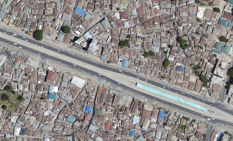
OpenAerialMap (OAM) is a set of open source tools and an online platform for searching, sharing, and accessing openly licensed satellite and drone imagery.
Project solution
This project offers [specific solution or intervention] to tackle [challenge]. By implementing [strategies, tools, or innovations], the project aims to achieve [desired outcomes]. The approach is designed to [specific actions or methods] to bring about meaningful change in [community, region, or issue area].
Expected outcomes
This project aims to achieve [specific outcomes], such as [measurable results, improvements, or changes]. The expected impact includes [benefits to the target community, advancements in research or innovation, or long-term effects]. By the end of the project, we anticipate [specific changes or milestones] that will contribute to [broader goals or objectives].
WHAT IS THE HUMANITARIAN NEED?
Satellite and drone imagery is becoming increasingly available after a disaster. It is often difficult to determine what is available and how to access it easily. OAM seeks to solve this problem by providing a simple open way to host and provide access to imagery for humanitarian response and disaster preparedness.
WHAT IS THE INNOVATIVE SOLUTION?
After deploying OpenAerialMap in mid-2015 with funding from the HIF, the Humanitarian OpenStreetMap Team (HOT) working with humanitarian response agencies to help incorporate the platform into their activities. Following this by 2017, imagery had been contributed in Tanzania, Philippines, Nepal, Mongolia, Mexico and many other places across the world. Having such a global framework in place enables imagery to be contributed and sourced from a single location and means that responding organizations can save critical time locating imagery after a sudden onset disaster. Instead of waiting hours, days, or even weeks, value added activities (such as using the imagery to create base maps of affected areas, undertaking rapid damage assessments, and other analyses) can begin immediately; leading to more effective decision making during humanitarian crises.
WHAT DID THE PROJECT ACHIEVE?
Through the diffusion grant the project was able to:
- Partner with imagery providers to increase volume of data shared and available through OAM.
- Raise awareness among humanitarian organisations on the benefits of openly licensed imagery.
- Develop a communication (including social media) campaign and publish success stories about open imagery.
- Implement interoperability standards for OAM to work efficiently with GIS mapping software.


Project delivery & updates
Stay up to date with the latest developments from this project. Here, you will find details on what has been delivered, resources created, and regular updates as the project progresses. Access key documents, reports, and other materials to see how the project is making an impact.