
Early warning system for flood management in Vasai-Virar‚ Mumbai Metropolitan Region

Project overview
This project will provide an open platform to citizens and decision makers that will provide and early warning system and flood maps on near-real time basis. This will help flood risk management and support in improving the flood responses
Project solution
This project offers [specific solution or intervention] to tackle [challenge]. By implementing [strategies, tools, or innovations], the project aims to achieve [desired outcomes]. The approach is designed to [specific actions or methods] to bring about meaningful change in [community, region, or issue area].
Expected outcomes
This project aims to achieve [specific outcomes], such as [measurable results, improvements, or changes]. The expected impact includes [benefits to the target community, advancements in research or innovation, or long-term effects]. By the end of the project, we anticipate [specific changes or milestones] that will contribute to [broader goals or objectives].
WHAT HUMANITARIAN NEED IS BEING ADDRESSED?
City-level risk assessment is yet to be undertaken to enable/enhance the preparedness and response delivery mechanism. Without detailed hazard, vulnerability and risk assessment may limit response actions to target locations and groups/communities. Systematic collection, collation, maintenance and updating of relevant data are required to strengthen the warning mechanism.
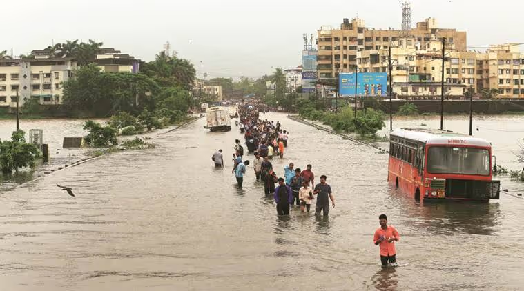
The city of Vasai-Virar, India, is an interesting case because of the increased vulnerability caused by changing demographics and developmental pattern which can potentially cause an increase in the frequency of disasters. The city's immediate needs are to ensure coordination and convergence of its developmental works, disaster resilience building and disaster risk reduction efforts.
Flooding being main cause in Vasai-Virar is heavy onsite rainfall aggravated by multiple factors like high tide, and drainage issues. In most cases, such situation sustains for few hours to days, due to which remote sensing data has limited use.
Effective early warning systems (EWS) are needed at city level primarily because of a lack of a standardized EWS framework, a lack of available warning information products and services at different temporal and spatial scales, and a lack of warning content that is unable to facilitate appropriate and timely decisions for those who are immediate risk.
WHAT IS THE INNOVATIVE SOLUTION AND HOW WILL IT IMPROVE EXISTING HUMANITARIAN PRACTICE?
The Aga Khan Agency for Habitat are developing an EWS which will be available as a web service, as well as a mobile app.
While both the app and web service will be open to citizens and decision makers - providing a real-time early warning system that can help streamline emergency alerts and information dissemination - they will have a different set of features. This divide has been made based on the technical requirements of the features and the differing needs of the public and the decision makers.
The system includes weather forecasts, flood models for various intensities of rainfall, real-time information on key pump status, sump and canal water levels, actual rainfall, inundation levels, among others; and a messaging system to provide warnings and real-time information to city officials and citizens.
The key features of system includes cost effective sensors, multi parameter monitoring of other climate related data, provision for crowdsourcing, modular capacity, cloud-based data collection, processing, and storage so all the stakeholders can have access to information through web browser and mobile phone apps anywhere.
Broadly the EWS mobile-app and web-portal will focus on flood risk mapping and near-real time reporting in the city and will show near-real time updates on alerts and the following information dissemination functions:
- Localised weather foresting
- Ward wise rainfall updates every 15 minutes
- High-tide schedule
- City level traffic updates
- Provision of bulk-SMS system
- Do’s and don’ts of disasters (3-4 mins animated audio-visual films)
- SOS
- Emergency contact numbers
- Flood reports from social media and messaging platforms which are then represented in publicly available map helping inform communities about the flood situation in near real-time.
EXPECTED OUTCOMES
The below outcomes are expected from the Aga Khan Agency For Habitat, EWS:
- Rapid risk assessment and feasibility study for EWS in city will be carried out.
- Prototype of applications will be developed.
- Mobile application for end user
Vasai will have a comprehensive forecasting system that provides real-time information on inundation, weather forecast, and other climate related data which will help improve the work and lives of various stakeholders like city administration, citizens, communities, humanitarian agencies, civil society and academia, private sector and various other stakeholders in the city.
Some of the key benefits of EWS will be:
- Effective and timely responses to emergencies
- Reducing impacts from flood induced traffic congestions
- Flood informed urban planning
- Reduce economic losses and impact on livelihood
- Improving flood awareness and safety at community level


Project delivery & updates
Stay up to date with the latest developments from this project. Here, you will find details on what has been delivered, resources created, and regular updates as the project progresses. Access key documents, reports, and other materials to see how the project is making an impact.