
OpenAerialMap

Project overview
Project solution
This project offers [specific solution or intervention] to tackle [challenge]. By implementing [strategies, tools, or innovations], the project aims to achieve [desired outcomes]. The approach is designed to [specific actions or methods] to bring about meaningful change in [community, region, or issue area].
Expected outcomes
This project aims to achieve [specific outcomes], such as [measurable results, improvements, or changes]. The expected impact includes [benefits to the target community, advancements in research or innovation, or long-term effects]. By the end of the project, we anticipate [specific changes or milestones] that will contribute to [broader goals or objectives].
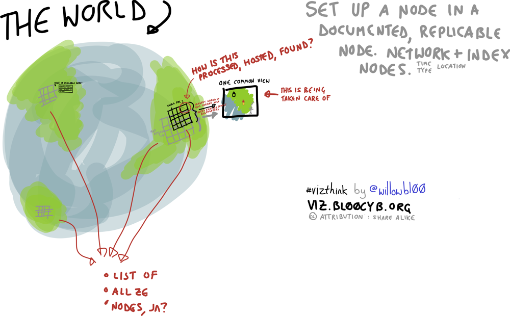
Imagery from satellites, Unmanned Aerial Vehicles (UAVs) and other aircraft is being generated more and more, however after a disaster it is difficult for aid workers to determine what imagery is available and where to access it. OpenAerialMap (OAM) seeks to solve this by providing a simple, open way to process and provide imagery for humanitarian response and disaster preparedness.
What humanitarian need is being addressed?
Reliable geographic information can be vital for decision making. Imagery from satellites, UAVs and other aircraft often serves as the base of this geographic information. Imagery can be utilised to create base maps of disaster prone areas, collect exposure data for risk and impact modelling and to discuss risk with communities. In relief coordination, imagery plays a similar roles as well as post-event imagery being useful in damage assessments.
How does the innovation build on and improve existing humanitarian practice?
Satellite imagery has been a component of humanitarian response for several years through the Disaster Charter. Now with cheaper satellites and the advent of low cost UAVs it is possible for more organisations and individuals to create their own imagery. With this increase in availability it is important that a service exists to coordinate such imagery and make sure responders can access it in a usable manner.
What did the project achieve?
The initial node of an OpenAerialMap was created and deployed. Detailed documentation and deployment instructions to set-up a new OpenAerialMap instance, and instructions for users, were created to support this initial node.
This project received further funding from the Humanitarian Innovation Fund to continue it's work. You can read more about it on the project page: OpenAerialMap Diffusion.


Project delivery & updates
Stay up to date with the latest developments from this project. Here, you will find details on what has been delivered, resources created, and regular updates as the project progresses. Access key documents, reports, and other materials to see how the project is making an impact.