
Innovators in the Protection of Endangered Heritage


Heritage sites across the Middle East have long suffered from various forms of vandalism, neglect, urban encroachment, and natural deterioration. But since the Arab Spring, with authoritarian regimes replaced by weak governments or failed states and with the rise of ISIS and its affiliates, these sites face the unprecedented threat of total destruction.
The Rt Hon John Whittingdale, introducing the consultation for the Heritage Protection Fund in 2016, highlighted the pernicious impact of such destruction. ‘Civilisations tell their stories through their art. Throughout history, culture and heritage have often been targeted for destruction by those who oppose others’ values, beliefs and ways of life. Removing cultural heritage including valued objects, and stifling freedom of expression attacks peoples’ shared sense of history and identity, and undermines social cohesion, making reconciliation less likely.
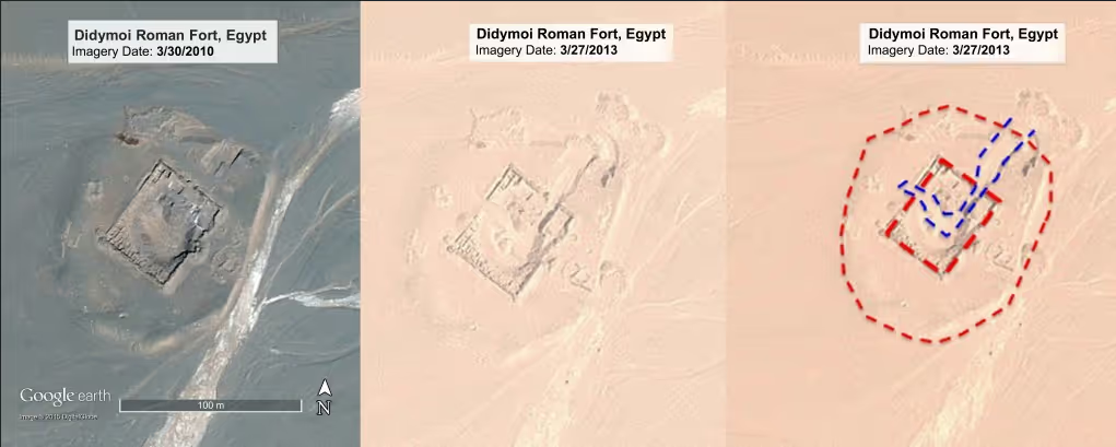
In response to this regional threat, EAMENA, supported by ARCADIA and based at Oxford University, has pioneered a region-wide approach to mapping endangered archaeological sites – using advances in satellite imaging. EAMENA’s primary aim is to rapidly record and evaluate the status of the archaeological landscape of the MENA region using satellite imagery in order to create an accessible body of data for use by national and international heritage professionals. This will allow them to identify sites that are most in danger and better plan and implement their preservation and protection.
The programme recognises that fieldwork and outreach are essential components of the project and the EAMENA team will target investigations to the most threatened sites, visiting (where possible) to assess site conditions, make detailed records and liaise with national authorities to share data and findings.
The importance of engaging local communities has been recognised as being vital both for sustainability and to help with operations in conflict-affected areas where the capacity of central Government may be limited. This HIF project seeks to demonstrate an innovative approach by using UAVs flown by local operators to provide much greater definition and greater community engagement.
A number of pilot programmes have sought to explore approaches to better community engagement, particularly in conflict affected regions. These include USAID’s ‘Sustainable Cultural Heritage Through Engagement of Local Communities Project’ (SCHEP). SCHEP aims to help communities preserve cultural heritage sites while simultaneously building the economy through increased employment and visitation. The European Union has a similar programme, Promoting Understanding of Shared Heritage (PUSH), part of its Partnership for Peace Programme, with additional support provided by the Norwegian Foreign Ministry and the Beracha Foundation.
In a separate programme called Patrimony for Peace, the European Union, through the UN Development Programme—Partnership for the Future has been supporting Cultural Heritage Projects to Build Bridges in Cyprus.
As well as these international initiatives, there have been local projects such as the one led by Heba Abd el Gawad, from Egypt’s Helwan University, to develop approaches to connect communities with their heritage, combining both educational and archaeological outcomes.
We have explored these existing approaches to look at the potential of our approach and scope for further innovation. The core idea is built on the scope for simplifying and improving the process of 3D mapping, modelling and monitoring to the point that it become accessible and cost effective enough to be deployed in a humanitarian context. It builds on advances in photogrammetry to go from 2D images to 3D topographical mapping and simulated models.
The simplicity and robustness of consumer tech based hardware and simple apps facilitates community engagement and in the longer term is likely to be more sustainable and scalable than the ‘international expert’ based approaches.
The potential of the digital imaging approach has been illustrated by other pioneers. Iconem, a French company has been using a mix of old and new images to assess damage done by Daesh and support reconstruction / restoration in Palmyra.
AMAL in Heritage is working on a mobile app designed to assist and provide tools for risk planning and emergency management and to help professionals and local communities if experts are not available. Global Heritage Fund is partnering with the Prince Claus Fund, the Arab Regional Centre for World Heritage (ARC-WH), and the International Centre for the Study of the Preservation and Restoration of Cultural Property (ICCROM), and the International Scientific Committee on Risk Preparedness of ICOMOS (ICOMOS-ICORP) to launch the ‘AMAL in Heritage’ programme.
Factum Arte has been demonstrating the potential of digital technologies and their role in the preventative conservation of heritage sites at a number of high profile sites around the world. The recent installation of an exact facsimile of the burial chamber of Tutankhamun into a new building at the entrance to the Valley of the Kings is a good example of this approach in practice. Factum Arte has worked with The Musée du Louvre, The British Museum, The Pergamon Museum, Museo del Prado, Biblioteca Nacional Madrid, the Fondazione Giorgio Cini, the Supreme Council of Antiquities in Egypt and many other museums.
Each of these programmes demonstrates the scale of the challenge as well as the importance of finding effective and efficient ways of empowering local communities to play a greater role in heritage stewardship.
Stay updated
Sign up for our newsletter to receive regular updates on resources, news, and insights like this. Don’t miss out on important information that can help you stay informed and engaged.

Related articles


Explore Elrha
Learn more about our mission, the organisations we support, and the resources we provide to drive research and innovation in humanitarian response.